tutorial to extract heightmaps from Google Earth in GEM Editor:
You will need:
-Google Earth : Earth.google.com
-a special plugin for Google Earth: Ambiotek.com
-MicroDEM Map Tool - Usna.edu
- Any photo-editing program that can save your file in TGA format (Photoshop, Gimp etc..)
1/ Install MicroDem program on your PC.
2/ Open Google Earth program and double click the Google Earth plugin file SRTM41.kmz (A new line “SRTM4.1” appear in the left menu of Google Earth). Double clic on it: You see the earth divided into sectors with numbers.
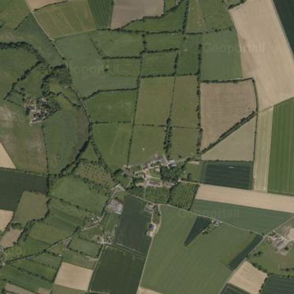
In my example, I want to import the 3d elevation of the village of Brettevillette, in Normandy (10km east of Caen/France. The number of this sector is STRM 36_03).
Maps.google.fr
3/This sector is too big to be imported, so you have to zoom on a lightest sector:
On the left of STRM 4.1, you will see a triangular icon. click on it and you will see a folder "elevation". click again on the 2nd triangular icon: you see all the sector of the planete earth.
Double click the link "data for STRM 36_03": A windows appear (wait 4/5 seconds)
4/ you can read: “Preview the tile in GE: srtm_36_03 : Click here to visualise terrain and access 1 degree tiles" : Clic on it, and you will see the initial sector now divided in 5x5 sectors, and the initial satellite view of Google Earth appear now in color with the elevation. Each new sector have a code. In my case, i want the heightmap of the sector STRM 36_03_5_5 that correspond to the village of Brettevillette.
5/A new line "elevation preview" appear in the left menu of Google Earth with a new triangular icon. click on it and you will see 2 folders: "Global legend" and "Local legend".
6/Now click the triangular icon of "global legend", and click the triangular icon of "Data"
7/Double click on the link "Data for: srtm_36_03_5_5": A windows appear, and then you have to choices to download the data: FTP or HTTP. Clic on HTTP to download the file. (take a long time to download it)
Now you have finished with Google Earth.
8/ The file is zipped: STRM_36_03_5_5.zip: Unzip it to have a file like that: STRM_36_03_5_5.asc
9/ Open MicroDEM program:
- Go to menu “File”, then “Open” and then “Open DEM” and clic your ASC file.A colored map of the sector appears but it’s too big to use it in GEM.
- Zoom on the map with the 6th menu (windows zoom) on the land you want to catch.Then you have a new zoomed colored map.
- Right clic on the map: “Display parameters”, then “Elevation” and choose the gray scale option.
- Right clic on the gray map: Copy to clipboard.
Now you have finished with MicroDem.
10/ Open Photoshop (or any program like Gimp etc.) :
- Create a new file, and copy paste the gray map. Crop the image to delete the 2 scale menus.
- Save it as TGA file.
11/ copy this file in the folder: “your Assault Squad folder”\resource\map\multi
12/ Open GEM Editor: Create a map (F2 Menu)
- Menu Heights => Import Heightmap => Map/Multi and you will see your TGA file ine the list. Clic on it and you have automatic the heightmap.
Note that the Gem Editor don’t accept too much high TGA files and if you map is too big, you may have problems. You have to experiment like me, because it’s not easy to find the correct scale.
To help, here is an aerial/satellite view of the village Brettevillette (save image as JPG).
I've transformed it in TGA file and I apply first this Heightmap file in the GEM to have the road, river, houses to draw my game map. After finish, I apply the real highmap (with near the same scale) and then you have a real heightmap for your game mission! ![]()
Have a look on my map of German skirmish mission "Brettevillette", and you will see that it goes! ![]()
Moddb.com
I hope it will help modders to do realistic maps for the great game Men of War and Assault Squad!
Regards.
Bassmaniac


Ehmm... My antivirus says that the microdem_setup.exe can make some bad things with my cumputer. Is that true? O.O
Nvm.. But my map always get like this: /\/\___/\/\/\/\____
Wierd.. o.o
You directly used your satellite image for your map: yes it's sharp but It help only to draw the roads, forests, houses (with textures) in their right place
After drawing that, you have to use the heightmap image (grey colors => no sharp relief) and apply it on your map (import heightmap in gem) and then you have a correct heightmap of your map zone.
Micro_Dem don't have virus in it.
regards.
Bass
The google maps works too with the microdem??
I followed all your steps and got the hight map an stuff but i wna follow ur advice on the satellite image for maping out the forests and textures and what not but idk how do u get a satellite hight map into the editor to do all that mapping out stuff. but other then that its a swell tutorial really helps out :)
in just really need help with the sattilite image to map out my areas on the map and trees and crap u kno so can u help me out?
First , your satellite image must be the same scale of your heightmap one. (you can use it also for the minimap).
This satellite image have sometime not enough contrast.
In this case, you can follow this method:
I use photoshop and do several specialized maps based on the satelite image. (You just have to think that black = hollows, White = bumps and middle gray is neutral = ground level 0)
Open the satellite image map and use it to define other layers: One for the roads (save the pic = one map), one for forests and the trees (1 map), the river, lake etc (1 map), 1 for fields (1 map), etc.. (each layer is use for a special thing in your map in Gem)
I choose a heavy contrast for each pic (save each layer to a Tga file) and then you can use it to have relief to place every stamps at his right place on the map.. at final, you apply the height map for global relief and Voilà: you have a real map with its real relief!
@bassmaniac,
i followed your instructions.
but my map is still too large after finishing step 3.
any way to select more small area?
the area i want is very small compare to any sector of that 5x5 matrix.
it is about 1.5 KM in wide and 3 Km in length .
another question:
"your satellite image must be the same scale of your heightmap one. (you can use it also for the minimap)."
how to get a satellite image?
here i am only getting options for snapshot and copy image.
which actually do same things.
but none of them giving me proper image to use as overlay on the terrian.
anyway thanks for this life saver tutorial.i was getting bored with cityengine.
like you i hit the printscreen key and copy image in Photoshop.
then , i can use it to create many overlays to halp for each part of the terrain.
The scaled procedure was also hard for me..
The map should not be to big if you don"t want to have problems of lag (and also use poly level 0 much as possible and use higher level only for details)
For minimap, you can find with google a lot of tutos
Hi bassmaniac,
For some reason MicroDem keeps saying that the files are corrupted.. :(
already solved :)
Thanks for this tutorial - works for me.
This comment is currently awaiting admin approval, join now to view.
This comment is currently awaiting admin approval, join now to view.
Hi people,
google maps strm plug-in is not working. Use this link to download the maps dwtkns.com/srtm/ by just clicking on the tile (region) of the globe that you need.
Could someone do an update about this tutorial now that the plugin for Google Earth doesn't work?
SRTM doesn't work.