Planetary engine that can be used with real elevation data of arbitrary resolution, while being progressively enhanced by fractal algorithms. The fractal algorithms refine and introduce details down to centimeter resolution and can be parametrized by elevation and land class data. A completely random fractal terrain is possible too, or a terrain can be sketched in rough resolution with fractal generating the details. Level of detail ranges from thousands of kilometers down to centimeters, with full visibility. The engine is fully asynchronous, majority of the algorithms running on the GPU while the rest is distributed to multiple CPU cores.
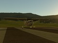
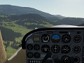
Cockpit view
(view original)

Post a comment
Now THIS is what I expected when I saw "Cockpit"
Video, I want, NOW. This looks great. Although I get that your really a terrain/planet engine, but damn thats a well modeled cockpit. Two concerns though.
1) Make sure that you include trees that aren't perfectly green. Evergreens may be easier to script/model/everything, but a huge field of evergreens doesn't come close to matching regular trees with their relatively wide range of colors.
2) You describe it as a "planetary" engine. Does this mean things like a dissappearing horizon actually are accounted for?
The indicators are now working, a video will be coming soon.
The trees are still that basic evergreen thing from a single land class, this will evolve as we'll be adding more climates and land types with vegetation.
The engine computes real time atmospheric scattering so under the right conditions there will be a disappearing horizon too. Currently however there is a bug that tints very distant land (>200km) orange so it actually stands out when it should be invisible on the sky background. This will be fixed soon.