Take part in one of history's most important wars which very few people know even happened, Take part in the war for Ireland! The war was fought between the four major Kingdoms and would define what the future of Ireland was to be! But that is not all for just across the sea lie the English, Scottish and Welsh all who are waiting for a chance to strike the divided Irish people. This mod will add new items, troops, empires, maps, cities and eventually quests and music. Who will you fight for; Connaught Ulster Leinster Munster or will you help the foreign kingdoms to capture the land that they desire!

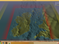
Until the whole map is completed this is all I will show as this is my plan on what the map will look like however it excludes the rest coast of England, Wales and Scotland which I will implement into the map.
Up to now I have only completed the Southern part of the map and will work on the north when I have some free time.
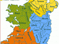
Mayo, Tyrone, John Kerry...You sure you're making a map of Ireland?
Yup,they're legit counties of Ireland.
In our good old Gaelic tongue, Kerry which is spelt Ciarraí in gaeilge (Gaelic) means people of Ciar. The C being the letter used in place of a K in tie Irish Language. These place names have all be renamed during the English occupation to be more pronounceable for English speaking peoples, another example is Tyrone, this means "Tir Eoghain" Tir means Land, like Tír na nÓg, meaning Land of youth, Tir Eoghain means Land of Eoghain. Eoghain being the Irish word for Owen, or in the modern Spelling, Éoin, which is still used in Ireland today. County Mayo or Contae Mhaigh Eo, means "Plain of the yew trees" as gaeilge.
Other examples,
County/Contae Sligo=Sligeach]roughly translates to an area with an abundance of shells.
Leitrim=[Liatroma] was an ancient town in one of the Irish kingdoms, the kingdom of Bréfni. The Kingdom of Breifne or Bréifne was a confederation of Irish túaithe headed by a ruirí drawn from the Uí Briúin Bréifne. The Bréifne territory included current day Irish counties of Leitrim and Cavan, along with parts of County Sligo.
County Roscommon=[Contae Ros Comáin] This land was part of Connacht, Ros dictates a secluded wooded area upon a height, and Comán is an Irish name of a person named... Comán, so it's named after some such man in ages past named Comán.
Galway-Gaillimh(Pronounced Gaul-Yiv] means city of the tribes and the surrounding land is named after the settlement. the word baile in Irish means town and Gail-imh is probably a change on that word that took place over a long period of time. The word Gal did not originally mean tribes though, it meant foreigner or stranger, a good example is the name Doyle in Ireland, The name is an Anglicisation of the Irish Ó Dubhghaill, meaning "descendant of Dubhghall or son ofDubhghall". The personal name Dubhghall contains the elements dubh "black" + gall "stranger". It's likely due to Irish people being patriotic that the people from Galway didn't want their city to mean "City of the Strange Foreigners" so the coat of arms in that county was subtly changed to "City of the Tribes" dispute the words not holding the meaning. [most people are morons so this has gone unchallenged]
During the Viking Age the term Dubhghoill was used to describe the Vikings—usually Danes—and the term Fionnghoill ("fair foreigners") was used to describe Norwegians. There is uncertainty as to the exact meaning of these terms. If they do not refer to literal colours of hair, complexion, or apparel, the terms could denote "new" and "old" Vikings. If correct, the terms may distinguish differing groups or dynasties, or perhaps represent ethnonyms referring to Danes and Norwegians respectively.
County Clare is Contae Chláir.
County Limerick is Contae Luimnigh, originally a Viking settlement. Later part of an Irish Kingdom which was called Thomond (Irish: Tuadhmhumhain; Modern Irish: Tuamhain)this kingdom was associated geographically with present-day County Clare and County Limerick, as well as parts of County Tipperary. The kingdom represented the core homeland of the Dál gCais people and although they ruled, there were smaller groups of other Gaels in the area. It existed from the collapse of the Kingdom of Munster in the 12th century as competition between the Ó Briain and the Mac Cárthaigh led to the schism between Thomond (North Munster) and Desmond (South Munster). It continued to exist outside of the Anglo-Norman controlled Lordship of Ireland until the 16th century.
County Cork is Contae Chorcaí, once ruled by the Eóganachta or Eoghanachta, an Irish dynasty centred on Cashel which dominated southern Ireland from the 6/7th to the 10th centuries, and following that, in a restricted form, the Kingdom of Desmond, and its offshoot Carbery, to the late 16th century. By tradition the dynasty was founded by Conall Corc but named after his ancestor Éogan, the firstborn son of the semi-mythological 3rd-century king Ailill Aulom. This dynastic clan-name, for it was never in any sense a 'surname,' should more accurately be restricted to those branches of the royal house which descended from Conall Corc, who established Cashel as his royal seat in the late 5th century.
Cork was later a part of The Kingdom of Desmond. located on the southwestern coast of Ireland. The name is Irish in origin – Deas-Mhumhain – which means South Munster. The Kingdom of Desmond originated in 1118, based on the Treaty of Glanmire, when the major parts of the prior Kingdom of Munster fractured into the Kingdom of Desmond and the Kingdom of Thomond (Irish: Tuadh-Mhumhain, meaning North Munster).
County Tipperary/Contae Thiobraid Árann. Following the Norman invasion of Ireland, the Kingdom of Munster was claimed as a lordship. By 1210, the sheriffdom of Munster [English Controlled] shired into the shires of Tipperary and Limerick. In 1328, Tipperary was granted to the Earls of Ormond as a county palatine or liberty.
County Wexford is called Contae Loch Garman. It is named after the town of Wexford and was based on the historic Gaelic territory of Hy Kinsella (Uí Ceinnsealaigh), whose capital was Ferns.
The town was founded by the Vikings in about 800 AD. They named it Veisafjǫrðr, meaning inlet of the mud flats, and the name has changed only slightly into its present form. For about three hundred years it was a Viking town, a city state, largely independent and owing only token dues to the Irish kings of Leinster.
The county is rich in evidence of early human habitation. Portal tombs (sometimes called dolmens) exist at Ballybrittas (on Bree Hill) and at Newbawn — and date from the Neolithic period or earlier. Remains from the Bronze Age period are far more widespread. Early Irish tribes formed the Kingdom of Uí Cheinnsealaig, an area that was slightly larger than the current County Wexford.
County Wexford was one of the earliest areas of Ireland to be Christianised, in the early 5th century. Later, from 819 onwards, the Vikings plundered many Christian sites in the county. Wexford town became a Viking settlement near the end of the 9th century.
Wexford was the site of the invasion of Ireland by Normans in 1169 at the behest of Diarmuid Mac Murrough, King of Uí Cheinnsealaig and king of Leinster (Laigin), which led to the subsequent colonisation of the country by the Anglo-Normans and later, the English. Many Irish people on the East cost have names that descend from Viking or Norman roots, as well as full blown English names in the later centuries.
I wanted to write more and copy some more stuff from Wikipedia for anyone who might dig this up, but... I'm gone tired and lazy now, hope some of this sparks some Interest in Gaelic history. I love history and my country has some really interesting linguistic changes regarding the switch from Irish to English spelt place names, often the meanings of the words changed so that they no longer made sense. It's really fun to dig it up.