Axis & Allies RTS new Map Patch Special thanks to theharkonnen for his tutorial on making new additional territories in WWII whitout which this would never be possible. In agreement with Gizmotron and theharkonnen I will combine all new territories for A&A RTS in a patch that can be installed in any mod including the original version by anyone having basic computer skills. Some of the RTS maps are very large and have lots of water so they take time to load be patient. Some are very small and they are a real dogfight.


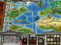
Mississippi Basin and Central America
Was able to correct Central America Mexico3.nif error in the dds to nif interface. Which was not allowing the alpha to show on the World Map
Axis & Allies RTS new "Map Patch" mod.
Sun 12-28-14
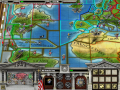
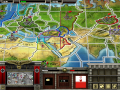
Screen shot from Uncommon Valor beta 2 will install in map patch next.
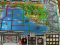
Central America Mexico3.nif File: Line named "WaterBorder.004" in Value Tree was missing "NiString" and "Nivertex" branches.
Copied both branches from "Water Borders" line located at the top of the tree and pasted them in line named "WaterBorder.004".
That corrected the nif allowing edited "Alpha" to appear on the world map.
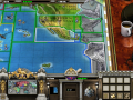
Same thing with Mississippi Basin and Western USA ,I just used the Western USA and Mexico original nif parent file to get the associated dds file "NiString" and "Nivertex" branches for "Land Borders", "Water Borders" and "Topography" and pasted them in the nif Value Tree at the appropreate line item for that dds number which was missing them. That corrected the nif allowing edited "Alpha" to appear on the world map.
Going to be a lot of work writing these two map border crossover territory data files.
These are the hardest territories to make work.