Central Africa, 1994. For decades, conflict has gripped this area of the continent and now it is about to get worse. Two rival factions are gearing up for open fighting.
The media you are trying to view has been deleted and is no longer available. This may have occurred at the uploaders request, or it may have occurred because it violated the sites Terms of Use. If this is a mistake and you would like it re-activated, please contact us with the details.
If you would like to view other media in this gallery click here.
Map by NinjaTheCat
"A few days after the PLACA invasion of the Central African Republic and Operation Savannah in the South, PLACA Chad and Sudan also launch an attack from the north in a similar fight. The PLACA Northern Army crashed over the border into CAFU territory with around 77,000 infantry, 300 artillery pieces and roughly 500 armoured vehicles, however, the CAFU army has been preparing for an assault from the North for days and has prepared a makeshift firebase at an abandoned United Nations airbase at Abou Deia just across the Chadian border.
At 09:00 hours, the PLACA launch an airstrike on CAFU positions at no loss to themselves yet. This is followed by the entire ground force about an hour later. CAFU forces may have mustered for some time but they were hugely outnumbered and outgunned. At around 03:00 the next morning, CAFU forces at Abou Deia were completely overwhelmed."
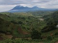
This map is set on a large Savannah plain in the Northern Central African Republic with dense Savannah vegetation providing cover for infantry as well as a few wrecks around the map. The PLACA starts with two uncappable deployment zones, one is a dirt airstrip to the top left corner of the map, the other is a dirt road with tanks and APCs. CAFU has about 3 capture points at the start, one is the UN Airbase but there is also a smaller camp nearby and a field radio base. In the center there is one or two neutral capture points.