Today's Friday Update, the second in our series on new random maps, will be all about Morea. Morea is one of K&B's Greece/Rumelia/Balkans maps together with the previously showcased maps of Bosphorus and Greek Archipelago and a few more that haven't been shown yet. Morea, called Peloponessos by the Greeks, is a peninsula in southern Greece, with perhaps a more interesting history than any other place in the world. The ancient cities of Sparta and Corinth were located on Morea and succesfully defended it from Persian armies far before our calendar started. Later the city of Corinth would become an important port and administrative center for the Roman Empire. In the Middle Ages, Morea was mostly held by the Byzantines, though it also served as a springboard for the overthrow of the Byzantine Empire in the Fourth Crusade by Veneto-Genoese Crusaders. In later centuries the region continuously changed hands between the Ottoman Empire and Republic of Venice, though between the fall of Venice to Napoleon Bonaparte, and the Greek War of Independence, Morea continuously belonged to the Ottomans, and these days it forms a major part of Greece.
Morea has a very high as-it-is value. Most of what you'll see in it, particularly the shape of the landmass in the map, is a carbon copy of reality. Most maps are designed to roughly resemble an area, or to no more of an extent than 'a sea in the east' or 'a desert in the middle'. Morea is not like that, and closely resembles the shape of the actual Laconian Gulf and surrounding areas. This is partially due to excellent research efforts by Pepp, though it must be said that the effort it has cost AOE_Fan to actually create it is far above average.

A river separates teams from one another in the north of the map
Not unlike last week, we'll scan the map in a linear fashion, with some text describing whatever we may encounter on our way. Last week we followed the region from west to east, this time we're going to start in the north of the map, bang in the middle of the Morean peninsula, and travel south towards the Laconian Gulf. With that, we immediately stumble upon something of note, that being a river. More specifically, the river Eurotas, which, it must be mentioned, has had many names. Eurotas, Iri, Bomycas and Himeras are several known names for it. In the Morea map, the Eurotas is a river which separates the map from north to south, until it joins the Laconian Gulf further south. It does not have any shallows, and as such it cannot be crossed by land units. The river contains an abundance of fish, as does the majority of water on the map. While very realistic, the river would cause balance issues on Free-for-All games, and as such, it isn't there. This may seen unimportant, but the fact that in FFA games your enemies can reach you by land, while they need a navy to reach you in a team game, is a major difference.

The northern plateau is the place where player placement occurs
In the north of the map, on either side of the river (if it's present) is a flat area where most of the land resources of the map are concentrated. This is also where players are placed. In team games, each team will control a side of the river, while in FFA games, players are placed in a circle on the flats, each roughly equally far apart. In team games, each part of the flats is roughly shaped like a triangle, with one side bordering the river, another bordering the edge of the map, and the last one bordering the hills that we've yet to discuss. This makes for an interesting dilemma, though not one that is up to the player. Get placed closer to the river and more resources will be available to you, get placed further away and you'll have a position that's easier to defend. Either can be beneficial.

Steep hills and a treasure
I already mentioned them in the previous chapter, and I will tell even more about them now. Seen from the north of the map, two impassable hills converge together, until both run parallel to the Gulf of Laconia, where they continue until the end of the two minor peninsulas that are created by the Gulf. These hills may seem like a nuisance, but are actually of major strategic importance. As the hills are covered with impassable terrain, the only two ways of reaching the areas behind the hills are a very long walk and a naval invasion. Both ways involve going past the tip of the peninsula, so building some fortifications there should shield the areas behind the hills from all but the most determined attacker. No player ever starts behind the hills, but on Nomad games it may be worth considering setting up a base there. The strip of land between the hills, thus not offering much space for a base, and and it will take time to get there, but the excellent defensive position may just be worth it. Decisions, decisions...
This is also coincidentally the first screenshot from a map that shows a treasure. For the maps of K&B, we've partially rethought the treasure system, and even in areas that weren't changed, we've made it more orderly. Treasures are now split between several categories, and their place in the map is based on their category. The highest category is those of 'Relic Treasures', which have all to do with the Relic system we highlighted many Fridays ago in a previous Update. These treasures are rare, but offer powerful bonuses.

It wouldn't be an Age of Empires mod without berries
Further south we go, until we come across a sea. The Laconian Gulf takes up a large part of the map, and it is not without reason. Morea is a naval map, and naval control is absolutely essential to this map. Unlike Greek Archipelago, where the many islands never leave a part of the sea out of reach of defenses, the sea in Morea is wide and open. Naval dominance then is a matter of building ships, not taking anti-ship precautions. Morea also comes with a great length of easy to reach shores, beaches even, which provide for a great deal of naval invading, and offer little opportunity to stop the invasions of others. As most resources on Morea are located in the water, it's not as if you can ignore the sea either, exploiting the seas is an absolute necessity in order to keep your economy running. Building a Docks should be a high priority on Morea, and whereas other maps may allow you the luxury to postpone this until later ages, Morea prompts you to do it in the Village phase. Get to Town phase instead and you're likely to be too late. Surviving without naval control isn't impossible on Morea, but it is very difficult indeed.

Two islands break the monotone blueness of the Laconian Gulf
To make matters even more interesting, naval control will also enable you to build a second base on one of the two islands that are present on this map. The islands already contain one Barbarian settlement each, and offer some more land resources, might you need them. Building a Docks or two on an island, alongside your usual ship-producing buildings, makes sense, as it will allow your ships to be repaired in the vicinity of where naval battles are likely to occur, the main bay. Some Towers on the islands will protect them from naval bombardment, and possibly from naval invasions as well. I just mentioned some Barbarians, but I guess some of you might be interested in them beyond the level in which knowing of their existence is enough. Well, each island always holds a single Barbarian settlement, and both are always Goths, so you'll be able to train the Goth Old Guard we showed you a couple of weeks ago. The Old Guards can be used in your main army, but being a Barbarian unit they take up no population whatsoever, and as such they make for an excellent defensive force on the islands, giving those some extra protection from possible naval invasions.

All olives on these trees belong to the state, and none shall be picked
Morea has a very uneven distribution of resources, though that's mostly deliberate. The majority of resources is located in the sea, with the land containing some herds of Deer and Copper Mines to keep up food and coin production in times of need, and some Olive Trees to attain the necessary wood. Some careful thought is required for the latter, as ships cost mainly wood, and while Morea does have rather some of it, the availability isn't endless, not even with the islands taken into account. It is possible to buy wood if you run out of it, but this is always more expensive than gathering it directly. Fortunately, Morea has an infinite supply of coin through whales, which dot the seas. Food is available in numbers of plenty as well, not so much due to the Fallow Deer that walk the land, but mainly because of fish in the sea. The river contains some, and so does the Laconian Gulf, though it must be said that the majority of fish is located in the smaller seas behind the hills. If you have no control of the seas, try building your economy on agriculture. Some Berry Bushes are present, but they're hardly of any significant quantity.
That should have been it for this week's Friday Update, but we've added a little extra, partially because we were planning to include it at some point anyway, and partially because we care about what the public would like to see. Last week there was no minimap in the update, and in our constant attempts to get better at what we do, this week's does contain one. You asked for it, now you have it.
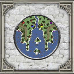
A typical minimap for Morea on a four player team game, just after game start.
PS: If one were to rotate the map 180 degrees, the shape of the land roughly coincides with a person sticking up both middle fingers. Please don't complain about it, we noticed that ourselves. Thanks in advance.
- Quoted from peugeot407