Before I say anything I would like to thank "Night Hawk" for his excellent tutorial about the process we will go over today for advanced terrain generation. This tutorial will cover advanced heightmap terrain creation and when I speak of "advanced" I mean more realistic than programs like TerraGen can provide with the same amount of effort, if not less.
Using another program called L3DT, a Windows application for generating terrain maps and textures. It is intended to help game developers and digital artists create large high-quality 3D worlds. TerraGen although nice does not allow for as much input, precision and also lacks certain capabilities such as a fast and flexible fractal 'inflation' based heightfield generator, including effects such as erosion, terraces and cliffs, volcanos, mountain peaks, etc., all of which are controlled from the design map.
Some of the other amazing things this program does that TerraGen does not:
- A texture generator for high-resolution interpolated ground texture maps, as well as the ability to generate alpha maps for run-time ‘texture splatting’.
- A extensible climate modelling engine for controlling the distribution of ground textures, including water-table and salinity modelling. Supports up to 65,000 unique and user-definable land types per map.
- Automatic and manual water-flooding routines, for making sea and lakes at different water levels.
- A fast light mapping module for pre-calculated terrain lighting and shadow casting, including high-resolution light mapping and bump mapping.
Using these unique features we can easily create epic looking heightmaps and textures for our maps. If outdoor environments are heavily utilized and not used to compliment, then this is a real world solution that can save you many hours of frustration and produce quality results.
In this two part video your will learn the following:
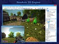
- How to create heightmap terrain for NeoAxis using program L3DT (Large 3D Terrain Generator).
- How to export texture map for entire heightmap terrain and apply it to terrain as 1 large image.
- Generate Alpha Masks for each seperate layer of terrain: sand, grass, rock based on percentage of land coverage.
- Make sandy beaches and beautiful cliffs with sand that lines up perfectly with your water plane, jagged rocks and cliffs that blend with your grass perfectly!
- Use normal maps to raise the detail level of your terrain with just addition of 1 special texture.
Links to Software Used
L3DT Standard Edition:
Bundysoft.com
Links To Videos
Part 1:
Part 2:


nie but is there a way i cn get a hieghtmap as detailed as this? Youtube.com