Players may find the changes to the deck bonus values may affect the context of play dramatically, this is designed in a purposeful manner which underscores the doctrinal needs of the respective ARMY (SHAPE) planners and their estimates of what form of threat the WARSAW forces would pose to the NATO and its combat effectiveness against a WARSAW force.
The year for the campaign timer begins in 1979, this is the most likely year the Russians would have decided to attack (US morale and troop strength was at its lowest just after the Vietnam war) had STAVKA been given permission to begin planning their attack against the NATO force in West Germany after ’79 the chance of a Russian attack across the Fulda gap diminishes by roughly ten percent (10%) each year until 1989 when a general withdrawal of Soviet forces in east Germany is announced and the reunification of Germany begins.
Named locations were peacetime barracks positions. Prior to hostilities, all units would deploy to their wartime General Defense Plan (GDP). There were three wartime scenarios that could have occurred. The first was where the Warsaw Pact attacked directly out of their barracks locations with only a few days of preparation, depending on strategic surprise, NATO would have had about 48 to 72 hours warning. This was the scenario NATO feared the most.
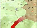
The second, and most likely, was a 7 to10 day warning with REFORGER units moving into place and the Soviets mobilizing for 2 to 3 weeks. The last scenario would have allowed full deployment for both sides. A nuclear exchange was a high probability in the 11th and 13th scenarios. There are other factors, which affect the general disposition of forces and their deployments, the purposes of the engagement scenarios are as follows the soviets are launching an assault with no warning from their station areas through The core of this corridor, which begins in the region of Erfurt-Eisenach and crosses the Border in the Phillipstal-Rasdorf sector (the sector between our OPs xxxx and Alpha).
From there it runs west to the gap between the Vogelsberg and the highlands north of the Autobahn. The broad corridor that begins at that gap and runs astride the autobahn all the way to Frankfurt and the Rhine is known specifically as the Wetterau Corridor. When you reflect on the last month of World War II you will recognize that the Wetterau Corridor and what we now know as the Fulda Gap served as the main avenue for the drive of the Third U.S. Army from its Rhine bridgehead near Frankfurt onward to Leipzig and the heart of Germany. (At one point in April 1945 Third Army HQ was in Hersfeld.)
In the Cold War Soviet war planners from the Eight Guards Army Staff near Weimar all the way to the Ministry of Defense in Moscow probably had a codename for this avenue in the westbound mode. Maybe it was "Rhinegate". (We will update this line when we learn exactly what they called it.) Anyway, you do not have to be a war planner to look at the map of Germany and recognize that the shortest** route from East Germany to the Rhine River was THIS avenue.
** See map (The alternate avenue, the North German Plain - region between the Berlin-Cologne autobahn and the North Sea coast, is traversed by two major rivers and a maze of shipping canals with steep banks. Its is about twice as long as the Fulda Gap and its reaches the Rhine where it is about twice as wide as in the Frankfurt - Wiesbaden sector.)
If the Eight Guards Army was deployed to forward positions before the outbreak of war its engineers would have needed bridging for only one secondary river, the Fulda, and that river was sometimes fordable in late summer. For the more probably scenario, a short warning attack (with no preliminary deployment from kasernes and training areas), some bridging could also have been needed for the Werra River.
When US military planners first found a need for a name to identify this probable axis of Soviet attack there may have been a debate as to whether it should be named for Fulda or Bad Hersfeld. Probably it was resolved in favor of Fulda because that was the better-known city and its name was more user friendly (easier to say and write).